Abstract's details
Analog data-driven strategies for the reconstruction of altimeter-derived SSH fields
Event: 2017 Ocean Surface Topography Science Team Meeting
Session: Science III: Mesoscale and sub-mesoscale oceanography
Presentation type: Poster
Ronan Fablet (1), Redouane Lguensat (1), Phi Huynh Viet (1), Ge Chen (2), Bertrand Chapron (3)
1IMT Atlantique; UMR 6285 LabSTICC, Brest, France
2Ocean University of China, Qingdao, China
3Ifremer: UMR LOPS, Brest, France
Event: 2017 Ocean Surface Topography Science Team Meeting
Session: Science III: Mesoscale and sub-mesoscale oceanography
Presentation type: Oral or Poster
Multi-satellite measurements of altimeter-derived Sea Surface Height (SSH) have provided a wealth of information about ocean circulation and atmosphere-ocean interactions. Numerous improvements have been brought to the optimal interpolation of daily SSH fields from along-track data. Yet, horizontal scales below 100km remain mainly unresolved.
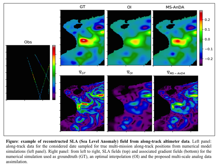
In this work, we explore analog data-driven strategies for the reconstruction of SSH fields from along-track altimeter data including possible synergies with other sea surface tracers such as Sea Surface Temperature. Broadly speaking, within a state-space setting, analog strategies rely on matching current observations or states to previously observed or simulated ones to infer the state of interest (here the SSH). Using optimal interpolation as a low-resolution condition, we investigate such analog strategies [e.g., Lguensat et al., 2017] for the reconstruction of the high-resolution component of the SSH fields. This framework may be regarded as a two-scale assimilation model, combining a classical optimal interpolation for the low-resolution component and an analog assimilation for the high-resolution component.
We evaluate and demonstrate the relevance of such analog strategies using an OSSE (Observation System Simulation Experiment) case-study in the China Sea. We report gain in the reconstruction error up to 20%-30% compared with an optimal interpolation. Spectrally, this improvement mainly refers to horizontal scales between 50km and 100km. We further discuss the relevance of the proposed analog strategies for the synergy between high-resolution ocean models and satellite-derived measurements compared with classical data assimilation strategies.

Contribution: poster_ostst2017_rfablet.pdf (pdf, 1277 ko)
Back to the list of abstract