Abstract's details
Corsica: linking historical and current missions with Sentinel-3A
Event: 2016 SAR Altimetry Workshop
Session: SAR mode performances: SAR CALVAL from Cryosat-2 and Sentinel-3
Presentation type: Oral
In collaboration with the CNES and NASA oceanographic projects (T/P and Jason), the OCA developed a verification site in Corsica since 1996. CALibration/VALidation embraces a wide variety of activities, ranging from the interpretation of information from internal-calibration modes of the sensors to validation of the fully corrected estimates of Sea Surface Heights using in situ data. Now, Corsica is, like the Harvest platform (NASA side), an operating calibration site able to support a continuous monitoring with a high level of accuracy: a ’point calibration’ which yields instantaneous bias estimates with a 10-day repeatability of around 30 mm (standard deviation) and mean errors of 3-4 mm (standard error). For a 35-day repeatability (ERS, EnviSat, SARAL/AltiKa), due to a smaller time series, the standard error is about the double (~7 mm).
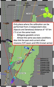
The locations of the Ajaccio (ERS & Envisat legacy) and Senetosa (T/P & Jason legacy) calibration sites are overflew by the Sentinel-3A pass #741, allowing to determine the SSH bias from both sites within a distance of ~37 km and a time lag of ~5 s. This situation will allow to mitigate geodetic errors of each site and will allow linking the past and current other missions (T/P-Jason and ERS-Envisat series). In order to perform the calibration over a longer segment of pass, we plan to make the connection of the Ajaccio and Senetosa local geoids along the Sentinel-3A track.
A first data set from the PDGS has been delivered to the Sentinel-3A Validation Team (S3VT) in June and the first results from the Corsica site show:
- An improved data quality in coastal areas thanks to SAR
- A very good agreement between SARM and PLRM (SARM-PLRM = -4.8 ± 3.8 mm) over both sites
- The absolute SSH bias derived from Ajaccio tide gauge (for cycle 2 & 3): SARM = -31.0 mm / PLRM = -24.2 mm
Contribution: SAR_06_Corsica-Bonnefond-SAR_workshop_2016_15h15.pdf (pdf, 872 ko)
Back to the list of abstract