Abstract's details
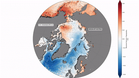
Sea level maps of the Arctic (and southern) ocean from satellite altimetry from 2011 to 2021
Event: 2023 Ocean Surface Topography Science Team Meeting
Session: Science IV: Altimetry for Cryosphere and Hydrology
Presentation type: Forum only
In the polar regions satellite sea level observations are limited by the sea ice. Thanks to a dedicated processing, sea level can however be estimated within fractures in the ice (leads) enabling to produce continuous sea level maps including the ice-covered region.
Maps and along-track of sea level for the Arctic (Prandi et al., 2021) and Southern (Auger et al., 2022) ocean were produced over 2011-2021 by combining measurements of 3 satellites from 50°N/S to 88°N/S through optimal interpolation. The three satellite missions (Sentinel-3A, SARAL/AltiKa and Cryosat-2) are processed using the same standards and are in great agreement. The along-track data were ingested in the new CNES/CLS22 mean sea surface solution and in a prototype of global sea level maps. The products are provided on the Aviso Regional Products portal and serve as demonstration products for the future generation of operational CMEMS-SLTAC products.
The sea level maps are validated against hourly Gloss/Clivar tide gauge at Prudoe Bay and monthly PSMSL tide gauges. It is also compared to bottom pressure recorders at the north pole and in the Beaufort sea (BGEP project) showing great correlation at monthly timescale. At inter-annual timescale, the product sea level and steric height from in-situ profiles (BGEP project) show the same evolution in the Beaufort sea. Sea level trends are also estimated from this product and compared to model trends.
Perspectives for this polar product includes improvements in processing and extension of the products backwards using ENVISAT altimeter and forwards using new altimeters.
Contribution: SC42023-Sea_level_maps_of_the_Arctic__and_southern__ocean_from_satellite_altimetry_from_2011_to_2021.pdf (pdf, 1796 ko)
Back to the list of abstract