Abstract's details
AlTiS Software for generating Time-Series of Water Levels from Radar Altimetry Data
Event: 2022 Ocean Surface Topography Science Team Meeting
Session: Science IV: Altimetry for Cryosphere and Hydrology
Presentation type: Poster
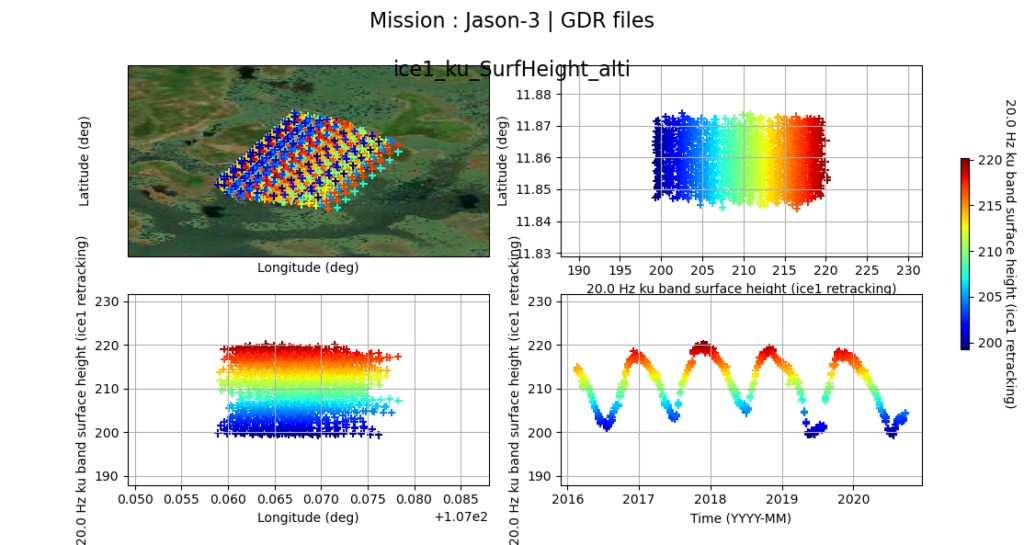
AlTiS (Altimetry Time Series) is a software to visualize and process radar altimetry data. It was developed to analyse radar altimetry data over small areas like river, lakes and wetlands, located in the altimetry groundtracks. Its major goal is the creation of time-series of water levels from the height derive from the altimeter measurement but it can also be used to generate time series of any altimetry-based parameters (e.g., corrections applied to the range, backscattering coefficients, or brithness temperatures).
Through a Graphical User Interface (GUI), without any skills in data processing, the user can handle altimetry data in order to :
• Display several parameters of altimetric measurement like surface height, altimetric range, atmospheric corrections applied to the range to take into account the propagation delay of the electromagnetic wave through the earth atmosphere (ionospheric correction and wet and dry tropospheric corrections) and also to display some characteristic parameters of the waveform like the backscatter coefficient, and peakiness.
• Graphically select altimetric measurements to remove outliers and easily done owing to Landsat background image.
• Generate water height time series from the valid altimetry data previously selected
AlTiS accepts CTOH altimetry products (Level 2 GDR supplied by the CTOH). CTOH GDR data have been specifically conditioned to optimize the data size by making a geographical selection and includes the right altimetry parameters for hydrological studies.
AlTiS can process several altimetric data products from followed missions : Jason-1/2/3, ERS-2, ENVISAT, SARAL, Sentinel-3A/B, and soon, Sentinel-6/Jason-CS and the nadir altimeter onboard SWOT. They are supplied for free through a web request form on the CTOH website (http://ctoh.legos.obs-mip.fr/applications/land_surfaces/altimetric_data/altis).
AlTiS is mainly employed for hydrological applications and can be used for training courses on radar altimetry at bachelor or master levels. It is also a very convenient tool to analyse the radar altimetry data contained in the GDR over any type of land surfaces.
AlTiS is a software developed by CTOH as part of its activities as a National Observation Service. AlTiS is a free software and it is released as an open source under the CeCill License. Altis is working under python3 environment and tested for GNU/Linux, Windows 10.
AlTiS is available on GitLab : https://gitlab.com/ctoh/altis
Contribution: SC42022-AlTiS_Software_for_generating_Time-Series_of_Water_Levels_from_Radar_Altimetry_Data.pdf (pdf, 2159 ko)
Back to the list of abstract