Abstract's details
Altimeter Processing System – 2.0 (ALPS2)
Event: 2022 Ocean Surface Topography Science Team Meeting
Session: Application development for Operations
Presentation type: Poster
The Altimeter Processing System (ALPS) is the software run operationally at the Naval Oceanographic Office that daily processes satellite sea surface height observations into the form used for ocean predictions, hurricane heat content, and many other applications. This system has processed data since TOPEX/Poseidon with continued updates and advances for new satellites and sensors, quality control, and error estimation and removal. The system has undergone a complete rewrite and transition to operations in 2021 now processing Jason-3, CryoSat-2, AltiKa, Sentinel-3A, Sentinel-3B, and Sentinel-6A MF / Jason-CS. The accuracy measured in crossover RMS error is significantly better than the prior version. Output data will be provided in NetCDF formats with one file for each revolution of data. This will allow timely sea surface height, wave height, and wind speed. Legacy formats will be provided with a one year overlap.
An additional advancement is the ability to process swath observations as will be expected from the Surface Water / Ocean Topography (SWOT) satellite. Many quality control and error estimation processes translate to the swath observations, and additional estimation processes have been implemented. These include removal of estimated errors using the cross-track direction shape and filtering in the along-track direction based on the power spectral density estimation of the SWOT simulator. Evaluation of these error estimates so far shows that the energy content in simulations from realistic ocean models is larger than the expected errors represented in the SWOT simulator.
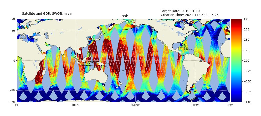
The SWOT simulator has been employed on regional and global model simulations. The results provided in the expected SWOT NetCDF format have been tested in ALPS2 for processing. The example in the figure below shows 10 days of data from the SWOT simulator sampling the operational Global Ocean Forecast System sea surface height. The simulator used all SWOT noise sources, and the simulator estimates of roll and phase error have been removed within the ALPS processing. This is the result of processing the simulated SWOT data through ALPS2. While the present ALPS2 is capable of processing SWOT now, we will be continuing to test the processing and assimilation of results into ocean forecasts systems up to the SWOT launch time. The ALPS2 system will be used during the SWOT cal/val with real time ocean prediction systems in the cal/val area for assimilation and demonstration of performance. The intent is to begin operational SWOT processing at NAVOCEANO at the end of the SWOT cal/val period.
Back to the list of abstractAn additional advancement is the ability to process swath observations as will be expected from the Surface Water / Ocean Topography (SWOT) satellite. Many quality control and error estimation processes translate to the swath observations, and additional estimation processes have been implemented. These include removal of estimated errors using the cross-track direction shape and filtering in the along-track direction based on the power spectral density estimation of the SWOT simulator. Evaluation of these error estimates so far shows that the energy content in simulations from realistic ocean models is larger than the expected errors represented in the SWOT simulator.
The SWOT simulator has been employed on regional and global model simulations. The results provided in the expected SWOT NetCDF format have been tested in ALPS2 for processing. The example in the figure below shows 10 days of data from the SWOT simulator sampling the operational Global Ocean Forecast System sea surface height. The simulator used all SWOT noise sources, and the simulator estimates of roll and phase error have been removed within the ALPS processing. This is the result of processing the simulated SWOT data through ALPS2. While the present ALPS2 is capable of processing SWOT now, we will be continuing to test the processing and assimilation of results into ocean forecasts systems up to the SWOT launch time. The ALPS2 system will be used during the SWOT cal/val with real time ocean prediction systems in the cal/val area for assimilation and demonstration of performance. The intent is to begin operational SWOT processing at NAVOCEANO at the end of the SWOT cal/val period.