Abstract's details
Baltic SEAL: new insights into the mean and variability of the sea level in the Satellite Altimetry era
Event: 2022 Ocean Surface Topography Science Team Meeting
Session: Science I: Climate data records for understanding the causes of global and regional sea level variability and change
Presentation type: Poster
For sea level studies, coastal adaptation, and planning for future sea level scenarios, regional responses require regionally-tailored sea level information. Global sea level products from satellite altimeters are now available through the European Space Agency’s (ESA) Climate Change Initiative. However, these global datasets are not entirely appropriate for supporting regional actions. For the Baltic Sea region, complications such as coastal complexity and sea-ice restrain our ability to exploit altimetry data opportunities.
This presentation highlights the opportunities offered by such regionalised advances, through an examination by the ESA-funded Baltic SEAL project (http://balticseal.eu/). We present the challenges faced, and solutions implemented, to develop new dedicated along-track and gridded sea level datasets for Baltic Sea stakeholders, spanning the years 1995-2019. Advances in waveform classification and altimetry echo-fitting, expansion of echo-fitting to a wide range of altimetry missions, and multi-mission cross calibration, enabled all mission data to be integrated into a final gridded product.
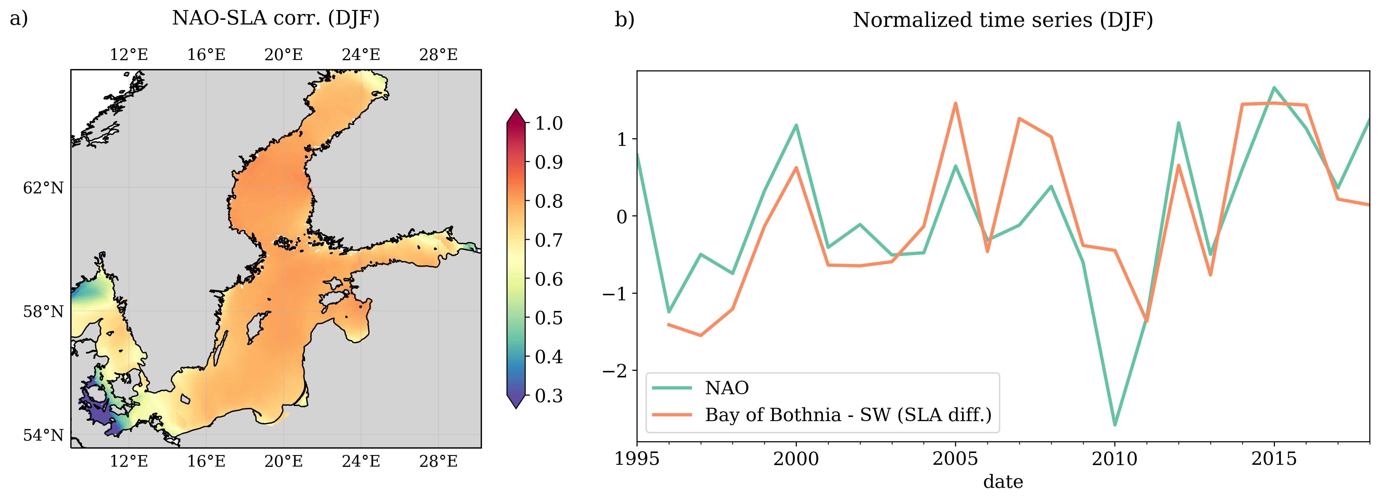
This gridded product provides new insights into the Baltic Sea’s mean sea level and its variability to be gathered. A Mean Sea Surface dataset was developed, in addition to an analysis of sea level trends in the region (using both tide gauge and altimetry data). The Baltic SEAL absolute sea level trend at the coast better aligns with information from the in-situ stations, when compared to current global products. A pronounced sea level trend gradient which increases towards the North-East was found. A proportion of the SL trend gradient can be directly linked to enhanced southerly wind forcing and associated Ekman transport towards the Bothnian Bay. The spatial and temporal density of the data allows for a robust comparison between the sea level time series and relevant climate indices such as the North Atlantic Oscillation, with implications for regionalising global climate change impacts. These investigations highlight the potential of regionalised products for the Baltic Sea region, and beyond, to study regional sea level variability.
Figure Caption: Panel a: correlation of the NAO index with SLA from gridded altimetry. Panel b: normalised time series of NAO index (green) and SLA difference between Bay of Bothnia (northernmost sub-basin) and south-west sub-basins (orange). Each point represents the time average of the quantities of the winter months December, January and February.
Back to the list of abstractThis presentation highlights the opportunities offered by such regionalised advances, through an examination by the ESA-funded Baltic SEAL project (http://balticseal.eu/). We present the challenges faced, and solutions implemented, to develop new dedicated along-track and gridded sea level datasets for Baltic Sea stakeholders, spanning the years 1995-2019. Advances in waveform classification and altimetry echo-fitting, expansion of echo-fitting to a wide range of altimetry missions, and multi-mission cross calibration, enabled all mission data to be integrated into a final gridded product.
This gridded product provides new insights into the Baltic Sea’s mean sea level and its variability to be gathered. A Mean Sea Surface dataset was developed, in addition to an analysis of sea level trends in the region (using both tide gauge and altimetry data). The Baltic SEAL absolute sea level trend at the coast better aligns with information from the in-situ stations, when compared to current global products. A pronounced sea level trend gradient which increases towards the North-East was found. A proportion of the SL trend gradient can be directly linked to enhanced southerly wind forcing and associated Ekman transport towards the Bothnian Bay. The spatial and temporal density of the data allows for a robust comparison between the sea level time series and relevant climate indices such as the North Atlantic Oscillation, with implications for regionalising global climate change impacts. These investigations highlight the potential of regionalised products for the Baltic Sea region, and beyond, to study regional sea level variability.
Figure Caption: Panel a: correlation of the NAO index with SLA from gridded altimetry. Panel b: normalised time series of NAO index (green) and SLA difference between Bay of Bothnia (northernmost sub-basin) and south-west sub-basins (orange). Each point represents the time average of the quantities of the winter months December, January and February.