Abstract's details
New regional Mean Dynamic Topography of Mediterranean and Black Seas from altimetry, gravity and in-situ data
Event: 2020 Ocean Surface Topography Science Team Meeting (virtual)
Session: The Geoid, Mean Sea Surfaces and Mean Dynamic Topography
Presentation type: Forum only
The Mean Dynamic Topography (MDT) is a key reference surface for altimetry. It is needed for the calculation of the ocean absolute dynamic topography, and under the geostrophic approximation, the estimation of surface currents. Those are required for a wide range of applications as the management of fishery resources, the monitoring of potential pollution, maritime security… Also, the MDT is the missing component for the optimal assimilation of altimeter data into operational ocean system as those run under the Copernicus Marine Environment Monitoring Services (CMEMS).
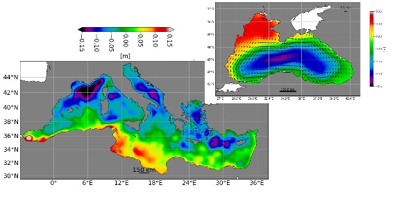
Mean Dynamic Topography solutions are calculated by merging information from altimeter data, GRACE and GOCE gravity data and oceanographic in-situ measurements from drifting buoy velocities and hydrological profiles. The objective of this communication is to present the new regional MDT of Black Sea and the newly updated MDT of Mediterranean Sea. The MDT in the Black Sea is the first to be carried out by CLS. It was built from the Eigen6c4 geoid model and the CNES-CLS15 Mean Sea Surface, and from drifting buoys velocities available from 1999 to 2009. The major novelty of updated Mediterranean MDT compared to the previous SMDT2014 solution (Rio et al 2014) is the use of the Eigen6c4 geoid model and the CNES-CLS15 Mean Sea Surface (instead of model output) in the first guess computation. Moreover, this new solution benefits from larger datasets: drifting buoys velocities (from OGS database, Menna et al 2017) from 1993-2016 (instead 1993-2011) and hydrological profiles (CORA database) available from 1993 to 2017 (instead of 1993-2011).
An evaluation of these new solutions compared to the previous versions and to other existing MDT is done through comparison to independent in-situ data, 20% (resp. 15%) of the data sets were kept for Black Sea (resp. Mediterranean Sea) MDT validation.
The Black Sea MDT has been compared to the previous MDT of Kubryakov et al (2011) computed from satellite and in-situ data with a different method. Compared to this MDT, the new solution shows better consistency with drifter’s data kept for validation, but the new MDT represents only large-scale structures. The updated Mediterranean Sea MDT globally improved performance compared to SMDT2014 (Rio et al 2014) but with less intense coastal currents (Algerian current, coastal current at east of Levantin basin and Asia Minor Current).
Contribution: OSTST2020_JOUSSET_MULET_MDT.pdf (pdf, 3586 ko)
Back to the list of abstract