Abstract's details
Volume Transport from In-situ and Altimetry Data Over a Wide Continental Shelf.
CoAuthors
Event: 2019 Ocean Surface Topography Science Team Meeting
Session: Coastal Altimetry
Presentation type: Type Oral
Contribution: PDF file
Abstract:
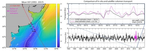
Within the French-Argentine CASSIS project, two bottom-mounted ADCPs were deployed for 11 months in the northern portion of the Argentine Continental Shelf at 60 km and 154 km from the coast, under Jason-2 satellite track #26. The direct velocities time series obtained are the longest measurements available in the region of study. We also constructed in-situ SSH using a coastal TG and the bottom pressure data from both deployments and inferred the associated along-shore geostrophic circulation. Results showed that the de-tided barotropic component dominates the circulation and that it responds to geostrophy. We also found that the variability of the circulation is uniform throughout the whole region. Therefore, the in-situ data resulted suitable for the estimation of the volume transport over the continental shelf, for the section under track #26 form the coast to the 200m isobath. The mean transport value obtained is of 2.4 Sverdrup (1 Sv is 106 m3 s-1) towards the NE for the whole period available, in good agreement with previous numerical model estimations. 20-day low-pass filtered in-situ transport correlates very good (0.7, 95% confidence level) with the transport estimated using satellite altimetry currents. We then computed a time series of satellite transport for the complete period available from altimetry data (25 years). The 25-year altimetry transport variability is dominated by the annual cycle, with maximum values during the austral autumn, and minimum values during the austral spring. Satellite transport is also influenced by oscillations between 12 and 60 days associated to the atmospheric forcing, as this region is continuously affected by the passage of both high and low-pressure systems. In particular, continental shelf transport presents a geostrophic response to local wind variability: when the along-shore wind stress flows to the NE, the sea level rises near the shore, which means that a sea level gradient is formed in the cross-shore direction, causing an intensification of the NE component of the along-shore transport. The opposite happens when the along-shore wind stress flows towards the SW. The present study shows encouraging results to the use of satellite altimetry in continental shelves. Yet altimetry data improvements are necessary to solve higher frequencies, especially for regions whose dynamics is strongly influenced by winds.