Abstract's details
Are global models correctly estimating water storage in major river basins? A comparison of remote sensed river channel storage and global model data
Event: 2019 Ocean Surface Topography Science Team Meeting
Session: Science IV: Altimetry for Cryosphere and Hydrology
Presentation type: Poster
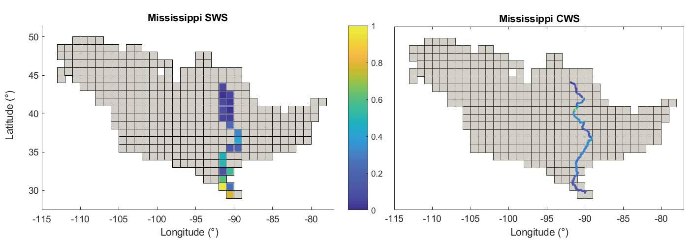
Observing the water cycle using Spaceborne remote sensing data is a focus across the scientific community. When considering components of the water cycle, surface water arguably has the largest impact on society. Properly accounting for variation in surface water storage (SWS) is essential for understanding the interplay between humanity and terrestrial water systems. Unfortunately SWS is a relatively small portion (~8%) of Terrestrial Water Storage (TWS). While TWS is somewhat well accounted for with GRACE measurements, SWS is difficult to distinguish. In the past SWS has been estimated in ways that ignore contributions from rivers, wetlands, floodplains and even lakes and reservoirs. Fortunately advances in land surface models have allowed for much better constrained estimations of SWS. However, model scaling and process binning (channel and flood plain storage) can create artifacts that may not be representative of actual SWS processes. The spatial representation of storage in highly active sections of river channels (those where complex hydraulic processes take place e.g., ice jams, or backflow at confluences), are particularly problematic. While the modeled representations of these rives may balance at the basin scale, using their data to evaluate potential for biogeochemical processes may be inaccurate. Using a combination of multi-mission radar altimeter and visual band remote sensed data, it is possible to measure channel water storage (CWS) for comparison with modeled data. We present a comparison of measured CWS and modeled SWS for 26 of the world’s largest rivers. Preliminary results show notable spatial variation in CWS ‘hot spots’ in 16 of the study basins. Modeled main stem river cell SWS climatological amplitude is between 33% -98% higher than measured CSC values from the channel only.
Back to the list of abstract