Abstract's details
Baltic+ SEAL: Building a Sea Level Product for Climate Research in a Region Featuring Jagged Coastline and Sea-ice Coverage
Event: 2019 Ocean Surface Topography Science Team Meeting
Session: Coastal Altimetry
Presentation type: Oral
The Baltic Sea, a semi-enclosed peripheral sea with depths up to 200 meters, features two conditions that severely limit the use of satellite altimetry in high latitude and coastal regions: (i) the presence of seasonal sea ice coverage, and (ii) the proximity of the coast. New improvements (such as the advent of Delay-Doppler, or SAR, altimetry), improved signal processing (retracking), and advances in sea-ice classification methods and geophysical corrections (wet tropospheric correction, sea state bias), have pushed the exploitation of altimetry observations at the regional scale. It is now necessary to explore these advances in a region which strongly features these conditions to improve product quality and applicability, particularly to high latitude and coastal regions. The European Space Agency-funded Baltic+ Sea Level (Baltic+ SEAL) activity is framed as a laboratory, in which advanced solutions in the pre- and postprocessing of satellite altimetry can be tested, and assessed for integration into global initiatives such as the ESA Sea Level Climate Change Initiative. The project will generate high spatio-temporal resolution grids of sea level anomalies to estimate sea level trends, produce an updated mean sea surface model for the Baltic Sea region, and map seasonal sea level variability. It is exploiting the full data resources available from the altimetry era, improving our understanding and the utility of altimetry for high latitude and coastal regions, through the use of the Baltic Sea region as a testbed. Here, the methodology underpinning version 1.0 of the dataset is presented. Among the processing steps we describe:
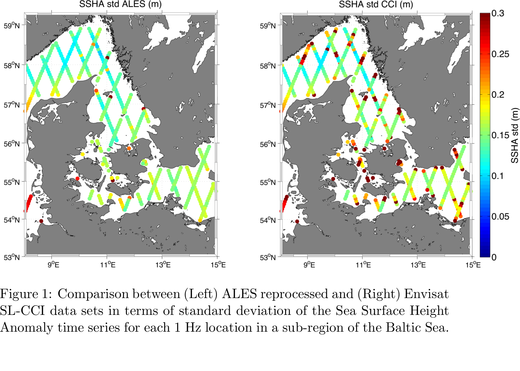
- The homogeneous retracking strategy applied for open-ocean, coastal and sea-ice conditions (ALES+),
- The unsupervised classification method developed to detect radar echoes reflected by open-water gaps within the sea-ice layer, and
- The development of the gridded product based on a triangulated surface mesh, characterised by a spatial resolution higher than 0.25 degree and enhanced utility for coastal areas.
The methodology is presented along with use of tide gauge data and external optical images to assess the reliability of current results and algorithms, as well as future development approaches.
The benefits of undertaking this activity are two-fold. Firstly, the advances update our current standards of sea level analysis, and best practice for the Baltic Sea region. Secondly, the activity is establishing a state-of-the-art altimetry processing chain, developed in a region specifically featuring two use-restricting conditions. This chain will be delivered in a manner that is easily exported to other key areas.
Back to the list of abstract- The homogeneous retracking strategy applied for open-ocean, coastal and sea-ice conditions (ALES+),
- The unsupervised classification method developed to detect radar echoes reflected by open-water gaps within the sea-ice layer, and
- The development of the gridded product based on a triangulated surface mesh, characterised by a spatial resolution higher than 0.25 degree and enhanced utility for coastal areas.
The methodology is presented along with use of tide gauge data and external optical images to assess the reliability of current results and algorithms, as well as future development approaches.
The benefits of undertaking this activity are two-fold. Firstly, the advances update our current standards of sea level analysis, and best practice for the Baltic Sea region. Secondly, the activity is establishing a state-of-the-art altimetry processing chain, developed in a region specifically featuring two use-restricting conditions. This chain will be delivered in a manner that is easily exported to other key areas.