Abstract's details
In situ calibration of satellite altimetric missions at the German Bight and Baltic Sea coasts
CoAuthors
Event: 2018 Ocean Surface Topography Science Team Meeting
Session: Regional and Global CAL/VAL for Assembling a Climate Data Record
Presentation type: Type Poster
Contribution: PDF file
Abstract:
We perform a regional in-situ calibration of the CryoSat-2 and Sentinel-3 altimeter data in Delay Doppler (DD) and pseudo low resolution mode (PLRM) along the German coasts of the German Bight and of the Baltic Sea.
For Sentinel-3A we use DD data from Copernicus and from the GPOD SARvatore service, retracked by the SAMOSA2 and SAMOSA+ retrackers respectively. The PLRM data are from Copernicus and from two in-house products derived from the FBR and retracked by TALES and the STAR retrackers. For CryoSat-2, DD data from GPOD and PLRM are in-house products. Homogeneous corrections for wet tropospheric (GPD+) and tidal corrections are applied to all datasets.
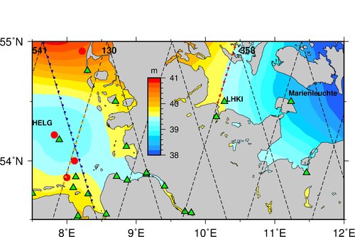
The in situ sea level records, chosen as ground truth, are from a network of in-situ and geodetic stations GPS@TG maintained by the German national organizations Waterway and Shipping Administration (WSV), the German Federal Institute of Hydrology (BFG) and the German Federal Maritime and Hydrographic Agency (BSH). The study includes a high quality local geoid and oceanographic models for sea level and wave heights data analysis as well as data processing and alternative corrections, like the GPD wet-tropospheric corrections (WTC). The regional ocean model data are taken from two models: the coupled Geestacht COAstal model SysTem (GCOAST) and the fine resolution BSH Model .
The first main aim of this study is to evaluate the reliability and stability of the altimeter sea surface height bias. The bias is computed as the mean of the differences between altimeter and tide gauge measurements at the overflights corrected for the ocean tide. First results at the Helgoland station show for Sentinel-3A SSH biases for the SAR mode of +22 mm +/- 60 mm and +35 mm +/- 45 mm. The standard deviation of the SAR SSH bias time series, which is smaller than for PLRM altimetry, is large due to errors in the tide model. Instead, for Baltic Sea stations, where the ocean tide is smaller, the standard deviation of the differences between altimeter and tide gauge SSHs reduces to 19 mm for GPOD and 21 mm for PLRM Marine. The difference between PLRM and the DDA biases do not present any temporal drift.
Precision, accuracy and noise level of sea surface height (SSH), significant wave height (SWH), and wind speed are analysed in terms of as functions of the distance to coast. Inter-comparisons between remote sensing and in-situ observations show an overall good quality, although the significant wave height from the satellites tends to overestimate the one of in-situ measurements by 7 cm to 30 cm. Analyses have been carried out, in which data from the satellite tracks are separated between onshore and offshore flights.as well as between the satellite tracks under varying metocean conditions.
We conclude that the network along the German coasts is suitable for validation and calibration of altimeters. The Baltic Stations as the most suitable to check the bias stability due to the small tidal regime. The Project GB_S3CVAL (German Bight S-3 Calibration and Validation) is part of the Sentinel-3 Validation Team (S3VT).
For Sentinel-3A we use DD data from Copernicus and from the GPOD SARvatore service, retracked by the SAMOSA2 and SAMOSA+ retrackers respectively. The PLRM data are from Copernicus and from two in-house products derived from the FBR and retracked by TALES and the STAR retrackers. For CryoSat-2, DD data from GPOD and PLRM are in-house products. Homogeneous corrections for wet tropospheric (GPD+) and tidal corrections are applied to all datasets.
The in situ sea level records, chosen as ground truth, are from a network of in-situ and geodetic stations GPS@TG maintained by the German national organizations Waterway and Shipping Administration (WSV), the German Federal Institute of Hydrology (BFG) and the German Federal Maritime and Hydrographic Agency (BSH). The study includes a high quality local geoid and oceanographic models for sea level and wave heights data analysis as well as data processing and alternative corrections, like the GPD wet-tropospheric corrections (WTC). The regional ocean model data are taken from two models: the coupled Geestacht COAstal model SysTem (GCOAST) and the fine resolution BSH Model .
The first main aim of this study is to evaluate the reliability and stability of the altimeter sea surface height bias. The bias is computed as the mean of the differences between altimeter and tide gauge measurements at the overflights corrected for the ocean tide. First results at the Helgoland station show for Sentinel-3A SSH biases for the SAR mode of +22 mm +/- 60 mm and +35 mm +/- 45 mm. The standard deviation of the SAR SSH bias time series, which is smaller than for PLRM altimetry, is large due to errors in the tide model. Instead, for Baltic Sea stations, where the ocean tide is smaller, the standard deviation of the differences between altimeter and tide gauge SSHs reduces to 19 mm for GPOD and 21 mm for PLRM Marine. The difference between PLRM and the DDA biases do not present any temporal drift.
Precision, accuracy and noise level of sea surface height (SSH), significant wave height (SWH), and wind speed are analysed in terms of as functions of the distance to coast. Inter-comparisons between remote sensing and in-situ observations show an overall good quality, although the significant wave height from the satellites tends to overestimate the one of in-situ measurements by 7 cm to 30 cm. Analyses have been carried out, in which data from the satellite tracks are separated between onshore and offshore flights.as well as between the satellite tracks under varying metocean conditions.
We conclude that the network along the German coasts is suitable for validation and calibration of altimeters. The Baltic Stations as the most suitable to check the bias stability due to the small tidal regime. The Project GB_S3CVAL (German Bight S-3 Calibration and Validation) is part of the Sentinel-3 Validation Team (S3VT).