Abstract's details
Measuring currents, ice drift, and waves from space: \\ the Sea Surface KInematics Multiscale monitoring (SKIM) concept
Event: 2017 Ocean Surface Topography Science Team Meeting
Session: Science III: Mesoscale and sub-mesoscale oceanography
Presentation type: Poster
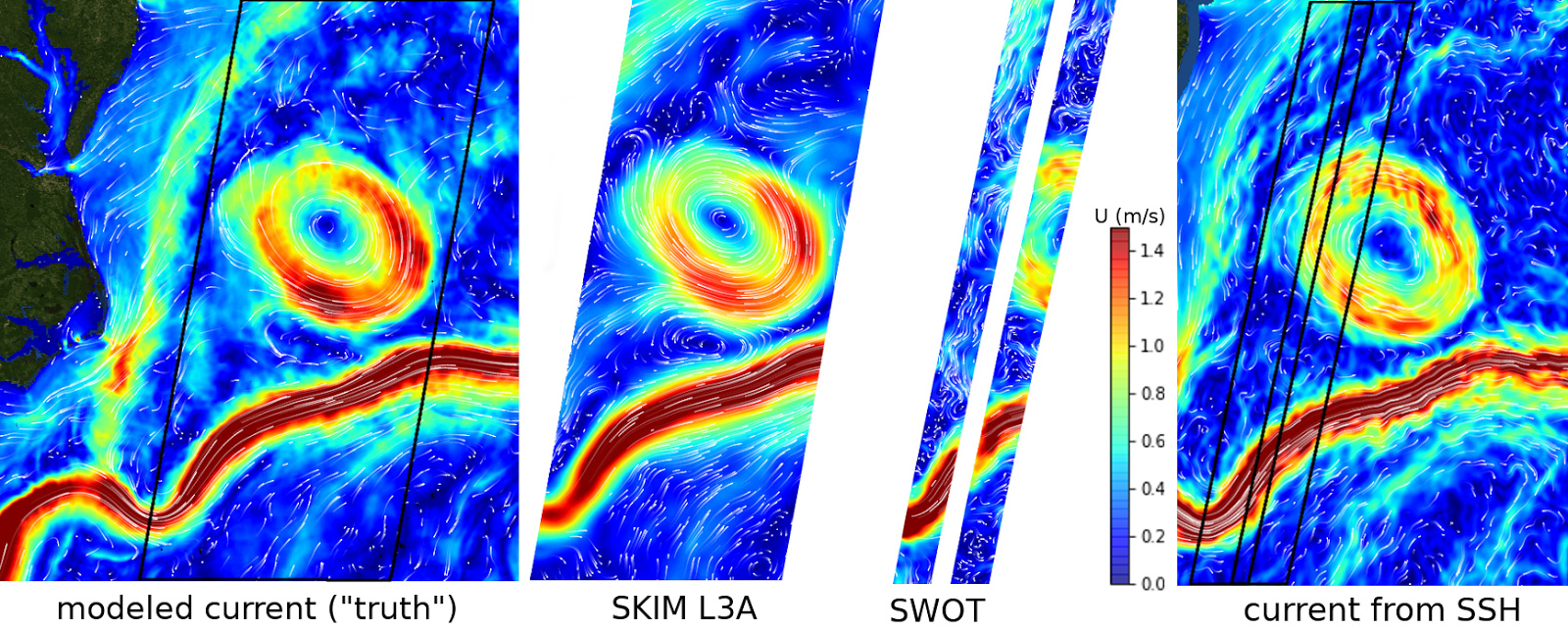
The Sea surface KInematics Multiscale monitoring mission (SKIM) has been proposed for ESA Earth Exporer 9, and its evaluation is under way. SKIM will open the era of satellite Doppler oceanography, combining nadir and near-nadir radar measurements. It will measure total ocean surface velocity vector (primary goal), using a Doppler technique that is more direct than altimetry for accessing surface currents, and ocean wave spectra (secondary goal). Planned as a five-year explorer experiment, this mission will address central questions for the understanding of our evolving climate, from the tropical current systems, to the rapidly evolving Arctic marginal ice zone. SKIM will demonstrate the maturity of Doppler oceanography, and pave the way for future Doppler missions. The proposed mission uses a high-resolution Ka-band Doppler altimeter, measuring at nadir and rotating off-nadir beams (0, 6 and 12° incidence angles). The expected accuracy on horizontal current velocity is 0.1 m/s, at a resolution of about 40 km. Flying on the 12 day-cycle Sentinel 1 (S1) orbit with a shift in longitude, SKIM will have a swath of 270 km that will allow overlap with S1 data and an ideal synergy for currents and wave sampling. SKIM will cover the world ocean up to 82° N, with daily coverage at latitudes beyond 70°, and an average of three passes per cycle at the Equator. This includes the Southern Ocean and both Arctic and Antarctic marginal seas. SKIM will image ocean current features, including eddies of diameter 80 km and more, a considerable extension of planned satellite altimeter missions capabilities. SKIM will also provide directional wave spectrum down to wavelengths of 20 m, and full azimuth coverage without direction ambiguity: these two aspects are clear improvement on existing and planned missions, giving a global coverage of oceans and regional seas.
In the context of satellite altimetry such a mission would be a unique opportunity to measure details of the sea state bias thanks to the measurement of the full ocean wave spectrum. SKIM will demonstrate that future altimetric missions can be modified to measure both sea level at nadir and currents over a swath, giving access to much smaller scales of the ocean dynamics. Efforts are under way to refine the error budget for SKIM ahead of a possible phase A in 2018. More details can be found in Ardhuin et al. (2007, doi:10.5194/os-2017-65). A particular concern is the wave-induced bias on the measured Doppler velocity. A preliminary analysis of simulated data and Ka-band measurements from a research platform support the 0.1 m/s accuracy for a 40 km pixel.
In the context of satellite altimetry such a mission would be a unique opportunity to measure details of the sea state bias thanks to the measurement of the full ocean wave spectrum. SKIM will demonstrate that future altimetric missions can be modified to measure both sea level at nadir and currents over a swath, giving access to much smaller scales of the ocean dynamics. Efforts are under way to refine the error budget for SKIM ahead of a possible phase A in 2018. More details can be found in Ardhuin et al. (2007, doi:10.5194/os-2017-65). A particular concern is the wave-induced bias on the measured Doppler velocity. A preliminary analysis of simulated data and Ka-band measurements from a research platform support the 0.1 m/s accuracy for a 40 km pixel.
Contribution: 20171020_SKIM_poster_OSTST.pdf (pdf, 2955 ko)
Back to the list of abstract