Abstract's details
Assessing the contribution of GOCE and altimetry to improvements in geodetic MDT determination
Event: 2015 Ocean Surface Topography Science Team Meeting
Session: The Geoid, Mean Sea Surfaces and Mean Dynamic Topography
Presentation type: Oral
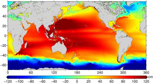
From the first gravity release of the mission, based on just two months of observations, it was clear that GOCE had improved our ability to measure the global ocean’s time-mean dynamic topography (MDT). Over the life of the mission four subsequent generations, based on an expanding set of observations, were produced, each computed by two independent methods. Here we track the improvement, in terms of decreasing MDT error, across releases and approaches, showing an ultimate convergence of the two approaches, with MDTs based on the final releases having an accumulated error of 5 cm at 100 km spatial resolution. This error also includes contributions from the MSS used in the calculation and numerical errors and we estimate the contribution from each of these sources. We also examine in a similar fashion how MDT error depends on the choice of MSS surface used, showing that while geoid errors swamp MSS errors at short wavelengths, the choice of MSS does have a noticeable impact at the 1 cm level on MDT error for spatial scales greater than about 130 km. A number of informal approaches are used to estimate MDT error and we compare the estimated geoid component of this informal error with the formal geoid errors derived from the full error variance/covariance matrices. Finally we assess the geodetic MDT approach using GOCE data in the context of alternative approaches to calculating the ocean’s MDT.

Contribution: GEO-05-RJBingham_OSTST2015.pdf (pdf, 2750 ko)
Back to the list of abstract