Abstract's details
Predictability of marine debris motion, simulated with numerical models and diagnosed using oceanographic satellite data
Event: 2015 Ocean Surface Topography Science Team Meeting
Session: Application development for Operations (previously NRT splinter)
Presentation type: Oral
Ocean mixing, induced by various ocean processes and ranging from unresolved (turbulence, breaking waves, tides, inertial oscillations, submesoscale eddies and fronts etc.) to under-resolved (mesoscale eddies) presents a challenge for general circulation models and other techniques utilizing oceanographic and meteorological observations to estimate motion of objects floating on or near the sea surface. At the same time, existing Global Ocean Observing System (GOOS) including a constellation of oceanographic satellites provides high-quality information that allows accurate description of surface currents and ocean drift on larger scales and longer periods.
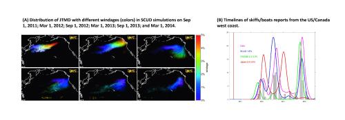
Complex dynamics of the air-sea interface make it difficult to directly measure or even to define “surface currents” and to separate drift due to these currents from the combined effect of wind waves and direct wind force (so-called windage or leeway). Generally, complexity of marine debris composition and rudimentary state of the marine debris observing system do not allow direct calibration of numerical models. Exceptions are data from “scientific” marine debris such as Lagrangian drifters and also from the accidents and catastrophes when particular items or large volumes are released nearly instantaneously from known locations. In this study we use three different models (SCUD, GNOME, and SEA-GEARN/MOVE-K7) to simulate motion and fate of marine debris (JTMD), generated by the tragic 2011 tsunami on the east coast of Honshu, Japan (A in Figure). Model assessments are compared with timelines of reports collected in the NOAA Disaster Debris, Japan Office of Ocean Policy, and IPRC/UH datasets (B in Figure). Models successfully simulate main peaks of JTMD arrival on the US/Canada west coast and after calibration provide an estimate of the total amount and location of the JTMD still floating in the ocean.
Other applications of the utility of oceanographic models, highlighted in this presentation, include identification of pathways and accumulation areas of general marine debris, routes of lost and rescued fishing boats and probable trajectories and fate of debris from the MH370 flight.
Figure caption. (A) Distribution of JTMD with different windages (colors) in SCUD simulations on Sep 1, 2011; Mar1, 2012; Sep 1, 2012; Mar 1, 2013; Sep 1, 2013; and Mar 1, 2014. (B) Timelines of skiffs/boats reports from the US/Canada west coast and three model solutions.
Contribution: APOP-06-Debris_Maximenko.pdf (pdf, 3692 ko)
Back to the list of abstract