Abstract's details
Performance analysis between autonomous tracker median and new version of OLTC mode
Event: 2015 Ocean Surface Topography Science Team Meeting
Session: Instrument Processing: Measurement and retracking (SAR and LRM)
Presentation type: Poster
The autonomous median trackers on-board the satellite altimetry missions have lower performances in the coastal zones and over the continental ice caps and waters (rivers, lakes, reservoirs), mainly because of the land contamination in the radar waveforms. As the number of satellite altimetry applications in these regions has significantly grown for a decade, some techniques have been developed in order to answer these new user requirements. In particular, the DIODE/DEM or OLTC (Open Loop Tracking Command) mode has been implemented with the objective to obtain a larger number of exploitable radar waveforms over these areas of interest.
The principle of the OLTC (Open Loop Tracking Command) mode consists in driving the altimeter with a priori information available on-board: real-time estimates of the satellite orbit with the DIODE navigator and theoretical height of the point located under the satellite, provided by a Digital Elevation Model (DEM) stored in the on-board memory and previously sampled along the satellite track. The sampled DEM is prepared pre-launch by assembling various elevations data: a Mean Sea Surface for ocean and coastal zones, a global DEM for continental areas, inland water elevations from specific databases and specific DEM over ice caps where available.
The Jason-2 and SARAL/AltiKa missions are currently flying with an on-board DEM. The analysis of the altimeter cycles operated in OLTC mode have shown the great interest of this technique in the areas of interest and some limitations. This study allowed us to identify improvement of new algorithms resulting in a more accurate on board DEM.
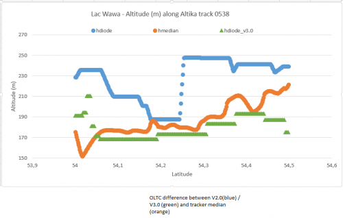
These algorithms show better agreement between the classic mode (autonomous median tracker) and the OLTC. We compared AltiKa on board DEM with the autonomous median tracker and the resulting new DEM produced with these new algorithms. Results over inland water and ice caps are very encouraging. On flight validation tools are developped to estimate in real time OLTC performance versus autonomous mode. The CNES and NOVELTIS will operate these tools during the first flight phases of JASON-3 and SENTINEL-3 missions.
Contribution: NOV-7464-SL-5723_POSTER_DIODE_NOV_OSTST.pdf (pdf, 1712 ko)
Back to the list of abstract