Abstract's details
High resolution SSH mapping with future satellite mission SWOT
CoAuthors
Event: 2022 Ocean Surface Topography Science Team Meeting
Session: Science III: Mesoscale and sub-mesoscale oceanography
Presentation type: Type Poster
Contribution: PDF file
Abstract:
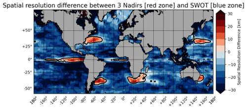
Sea Surface Height (SSH) information is available all over the world thanks to satellite altimetry measurements. Data processing and mapping algorithms produce sea level products that are part of ocean monitoring variables. In order to provide this information to marine environment actors, Copernicus Marine Service Program (CMEMS) created an operational ocean mapping algorithm called Data Unification and Altimeter Combination System (DUACS). This processing system uses data provided by currently flying altimeters (Sentinel, Jason, SaRal...) and supplies two types of SSH products : L3 (along-track) and L4 (gridded map). Next generation altimeter satellite SWOT will be launched late 2022 and will embark a new sensor based on Ka band. It will display high resolution SSH measurements on both side of its track across two swaths of 50 km. This is a major breakthrough because existing altimeters can only measure SSH along their tracks by pointing at nadir. All scientists and engineers of DUACS are hoping for new mission SWOT to improve the quality of L3 and L4 products. In that sense, this study focuses on the improvement in resolution of L4 gridded products thanks to SWOT satellite. In order to answer that question, 3 OSSEs were carried out in order to evaluate the performances of 3 different kinds of SSH observation systems : a) 3 Nadirs, b) 1 SWOT and c) 3 Nadirs + 1 SWOT. By comparing OSSEs one another it will be possible to assess both the performances of SWOT compared to 3 nadirs satellites and the benefit when SWOT is added to a 3 nadirs constellation. Results show that SWOT has a higher spatial resolution than 3 Nadirs at high latitudes, which is due to its high spatial sampling. At mid latitudes, SWOT enables to detect smaller structures only in low variability zones. Within energetic western boundary currents such as Gulf Stream or Kuroshio, 3 Nadirs constellation has a better temporal sampling and provides higher spatial and temporal resolution. In order to confirm these diagnosis, eddy detection algorithms were launched on SSH recontructed maps. Results show that detected eddies density is correlated with higher spatial resolution zones. The OSSE computing 3 Nadirs + SWOT data shows that the benefit of SWOT is unequal over the globe. It improves the spatial resolution everywhere, with limited effect in Western boundary currents and along the Equator. Yet, temporal resolution can get worse when SWOT is added, especially in zones where barotropic current is poorly evaluated.