Abstract's details
CryoTEMPO-EOLIS: Elevation Over Land Ice from Swath processing of CryoSat-2 SARIn mode data
CoAuthors
Event: 2022 Ocean Surface Topography Science Team Meeting
Session: Science IV: Altimetry for Cryosphere and Hydrology
Presentation type: Type Poster
Contribution: PDF file
Abstract:
Land-ice is declining globally, raising sea levels worldwide and impacting glacial risks and access to fresh-water in high-mountain glaciers regions. CryoSat-2’s primary mission objectives are to monitor the changes affecting the world’s sea-ice and large ice sheets to quantify thickness, mass trends and contribution to sea-level change. In practice, CryoSat’s revolutionary interferometric design has allowed several technical breakthroughs and led to the application of radar altimetry to environments that were previously unforeseen. One such breakthrough is Swath processing of CryoSat’s SARIn mode making full exploitation of the information contained in CryoSat’s waveforms and leading to one to two orders of magnitude more measurements than the conventional so-called Point-Of-Closest-Approach (POCA) technique.
Following on from the early demonstration of the technique and of its potential impact, the CryoSat ThEMatic PrOducts - SWATH Cryo-TEMPO” project aims to consolidate the research and development undertaken during the CryoSat+ CryoTop / CryoTop evolution / CS2 Mountain Glaciers ESA projects into operational products. The purpose of the thematic products is to make the data available to the wider scientific community in a form that does not require a detailed understanding of the sensor used and extensive post-processing. The first such product CryoTEMPO-EOLIS (Elevation Over Land Ice from Swath) consists of two distinct products; (1) a product containing point cloud of elevations with an associated uncertainty; and (2) a gridded product containing a spatial reduction of the point product onto a uniform grid of time-dependent elevation at 2km spatial posting and monthly temporal resolution, also with an associated uncertainty.
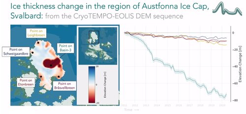
In phase one of the project, these two products were released over the Greenland and Antarctic ice sheets. As part of phase two, CryoTEMPO-EOLIS point products were generated over land ice outside of the two largest ice sheets covering glaciers in Arctic Canada, Iceland, Svalbard, Alaska, Russian Arctic, Southern Andes, High Mountain Asia, Greenland Periphery and Antarctic Periphery. Gridded products were also produced over the Vatnajökull and Austfonna ice caps in Iceland and Svalbard respectively. These new gridded products contain a pixel level uncertainty value, allowing the user to refine the pixels used based on the magnitude of uncertainty. This dataset will further the ability of the community to analyse and understand trends across land ice globally.
The poster will summarise the approach, provide an overview of the uncertainty and gridding methodologies, and show example use cases. The purpose of the presentation is to stimulate discussion and exchange ideas in the community about further useful products for user analysis and monitoring of climate change.
Following on from the early demonstration of the technique and of its potential impact, the CryoSat ThEMatic PrOducts - SWATH Cryo-TEMPO” project aims to consolidate the research and development undertaken during the CryoSat+ CryoTop / CryoTop evolution / CS2 Mountain Glaciers ESA projects into operational products. The purpose of the thematic products is to make the data available to the wider scientific community in a form that does not require a detailed understanding of the sensor used and extensive post-processing. The first such product CryoTEMPO-EOLIS (Elevation Over Land Ice from Swath) consists of two distinct products; (1) a product containing point cloud of elevations with an associated uncertainty; and (2) a gridded product containing a spatial reduction of the point product onto a uniform grid of time-dependent elevation at 2km spatial posting and monthly temporal resolution, also with an associated uncertainty.
In phase one of the project, these two products were released over the Greenland and Antarctic ice sheets. As part of phase two, CryoTEMPO-EOLIS point products were generated over land ice outside of the two largest ice sheets covering glaciers in Arctic Canada, Iceland, Svalbard, Alaska, Russian Arctic, Southern Andes, High Mountain Asia, Greenland Periphery and Antarctic Periphery. Gridded products were also produced over the Vatnajökull and Austfonna ice caps in Iceland and Svalbard respectively. These new gridded products contain a pixel level uncertainty value, allowing the user to refine the pixels used based on the magnitude of uncertainty. This dataset will further the ability of the community to analyse and understand trends across land ice globally.
The poster will summarise the approach, provide an overview of the uncertainty and gridding methodologies, and show example use cases. The purpose of the presentation is to stimulate discussion and exchange ideas in the community about further useful products for user analysis and monitoring of climate change.