Abstract's details
CWPIES, a shallow water current, waves and pressure inverted echo sounder for higher resolution satellite altimetry calibration and validation
CoAuthors
Event: 2022 Ocean Surface Topography Science Team Meeting
Session: Regional and Global CAL/VAL for Assembling a Climate Data Record
Presentation type: Type Forum only
Contribution: PDF file
Abstract:
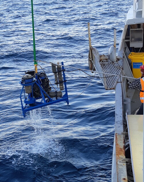
In view of the developing higher spatial resolution altimetry missions, we have been developing new in situ calibration/validation tools. In order to tackle the challenge of higher resolution radar altimeters, their sensitivity to wave or sea surface height heterogeneity within the footprint, we developed instrumentation to investigate more localised and higher frequency SSH signals. The Bass Strait cal/val area is situated in the South West of the strait and is now equipped for the historical Jason site, but also for Sentinel-3A and Sentinel-3B. The classic method that was used over the past decades included, besides a reference coastal tide gauge and GNSS site, permanent moorings recording bottom pressure, temperature and salinity through the column. The accurate vertical datum of this record is achieved by regular short-term occupation of the mooring sites with GNSS equipped buoys. Recently we added sub-surface kit with bottom mounted 5 beam Acoustic Profilers. These measure current profiles, but also complete wave spectra and Sea Surface Height in addition to the bottom pressure, temperature and salinity.
In this presentation we show the results from the past year where we had 4 of these CWPIES deployed (3 under the Sentinel-6 track with a 10km spacing and one under a Sentinel-3B crossover) from March to October 2021. We compare the measurements to the bottom pressure, seawater density variations and atmospheric pressure. We also compare the measurements to short term GNSS buoy occupations. We find that the acoustic system can track the surface at high frequency with cm accuracy. The drift of the bottom pressure sensor can be monitored. Changes in atmospheric pressure are also recorded by the system thanks to the inverse barometric effect difference between bottom pressure and acoustic surface ranging. We highlight the noise level and reliability of the system and practical use for the future use under Sentinel-6 and SWOT.
In this presentation we show the results from the past year where we had 4 of these CWPIES deployed (3 under the Sentinel-6 track with a 10km spacing and one under a Sentinel-3B crossover) from March to October 2021. We compare the measurements to the bottom pressure, seawater density variations and atmospheric pressure. We also compare the measurements to short term GNSS buoy occupations. We find that the acoustic system can track the surface at high frequency with cm accuracy. The drift of the bottom pressure sensor can be monitored. Changes in atmospheric pressure are also recorded by the system thanks to the inverse barometric effect difference between bottom pressure and acoustic surface ranging. We highlight the noise level and reliability of the system and practical use for the future use under Sentinel-6 and SWOT.