Abstract's details
Altimeter validation results from the Bass Strait validation facility, Australia
CoAuthors
Event: 2022 Ocean Surface Topography Science Team Meeting
Session: Regional and Global CAL/VAL for Assembling a Climate Data Record
Presentation type: Type Forum only
Contribution: PDF file
Abstract:
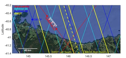
The Bass Strait altimeter validation facility (~ 40° 39’S, 145° 36’ E) provides cycle-by-cycle estimates of absolute altimeter bias for the Jason-series, Sentinel-3A and Sentinel-3B missions. The facility uses an integrated geometric approach involving a suite of in situ sensors including moored oceanographic sensors, episodically deployed GNSS equipped buoys, a coastal tide gauge and continuously operating GNSS reference stations. This year we present the results for the 4 missions with a focus on Jason-3 GDR-F and the Sentinel-6 1-Hz data.
With the advance of fully SAR capable altimetry (Sentinel-6) and in preparation for swath-based interferometric altimetry (SWOT), several enhancements to the Bass Strait facility have been progressed. We detail our ongoing use of 5-beam ADCP instruments for the determination of shallow water SSH, current and wave field information using a pressure inverted echo sounder concept (CWPIES). We review our progress in understanding small but significant systematic errors in SSH derived from GNSS equipped buoys. Together, advances in our in situ instrumentation seek to address an improved determination of along-track SSH (and SSH gradient) for the benefit of validating the next generation of altimeter missions. We present results from these investigations together with latest absolute bias results from the Bass Strait comparison points.
With the advance of fully SAR capable altimetry (Sentinel-6) and in preparation for swath-based interferometric altimetry (SWOT), several enhancements to the Bass Strait facility have been progressed. We detail our ongoing use of 5-beam ADCP instruments for the determination of shallow water SSH, current and wave field information using a pressure inverted echo sounder concept (CWPIES). We review our progress in understanding small but significant systematic errors in SSH derived from GNSS equipped buoys. Together, advances in our in situ instrumentation seek to address an improved determination of along-track SSH (and SSH gradient) for the benefit of validating the next generation of altimeter missions. We present results from these investigations together with latest absolute bias results from the Bass Strait comparison points.