Abstract's details
Interferometric Swath Radar Altimetry for the study of the Cryosphere
Event: 2022 Ocean Surface Topography Science Team Meeting
Session: Science Keynotes Session
Presentation type: Type Keynote/invited
Contribution: PDF file
Abstract:
Reference and repeat-observations of land-ice topography is critical to identify causal links between climate and ice trends, generate an accurate record of ice mass balance, and quantify land ice contribution to sea level change. Over the last 30 years, radar altimetry has been instrumental in monitoring ice sheets and their contribution to sea level change. Launched in 2010, the European Space Agency Altimetry mission CryoSat-2 was the first radar altimetry mission with a SAR/Interferometry radar altimeter payload. The aim of this new technology was to gain a better insight into the evolution of the cryosphere, in particular over the steep slopes typically found along ice sheet margins and glaciers where the majority of the mass loss is taking place. CryoSat’s revolutionary design features a Synthetic Interferometric Radar Altimeter (SIRAL), with two antennas for interferometry, the corresponding SAR Interferometer (SARIn) mode of operation increases spatial resolution while also increasing the accuracy of the geo-location by resolving the angular origin of off-nadir echoes occurring over sloping terrain.
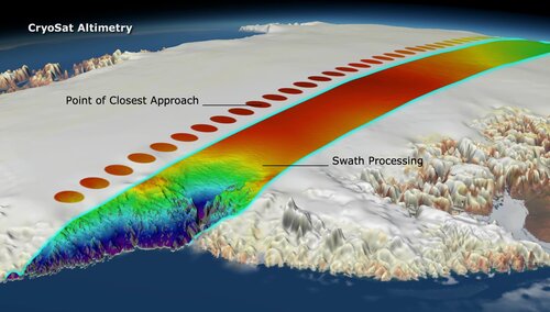
While the elevation of the Point Of Closest Approach (POCA), or level-2, is the standard product of the CryoSat-2 mission, the Interferometric mode of CryoSat-2 provides the ability to resolve substantially more than just the elevation at the POCA and thus led to a paradigm shift in radar altimetry of land ice. The so-called “swath processing” exploit the fact that over sloping terrain, CryoSat-2 altimeter operates in a manner such that the interferometric phase of the altimeter echoes may be unwrapped to produce a wide swath of elevation measurements across the satellite ground track, well beyond the POCA only. This technique provides the opportunity to increase spatial resolution and to recover elevation over regions where conventional radar altimetry fails; providing an opportunity to monitor land ice trends globally from radar altimetry.
Here I will discuss work done over the last decade to develop and apply swath processing over all components of land ice including the Greenland and Antarctic Ice Sheets, ice shelves, and glaciers worldwide, mapping ice mass balance, sub-glacial lakes, ice shelves melting, and improving the understanding of processes linking ice trends to climate forcing. Finally, I will discuss remaining challenges and the opportunities brought by CRISTAL whose primary mode over land ice will be SARIn and who will have swath processing as a core technology to derive time-dependant ice topography.