Abstract's details
A first assessment of swath processing for inland water
CoAuthors
Event: 2022 Ocean Surface Topography Science Team Meeting
Session: Science IV: Altimetry for Cryosphere and Hydrology
Presentation type: Type Poster
Contribution: PDF file
Abstract:
With an along-track resolution of around 300 m, ESA CryoSat-2 (CS2) brought along a whole new range of monitoring possibilities of inland water bodies. The introduction of Synthetic Aperture Radar (SAR) altimetry enabled the study of rivers and lakes that were not visible with conventional Low Resolution Mode (LRM) altimeters. However, the 300 m resolution is still a challenge for the smallest water bodies, for which sometimes none or only a single observation is available.
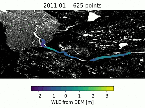
Over some selected water bodies, the CS2 altimeter operates in SAR Interferometric (SARIn) mode, using both the antennas on board. The phase difference between the two returns can be used to locate the across-track origin of the echo. While, traditionally, retracking methods are used to retrieve a single surface height estimate from waveforms over inland water bodies, in this study, we apply a swath approach where multiple peaks of single SARIn waveforms are retracked and geolocated across track using the phase difference information.
We show that this method can be used to retrieve a large number of valid water level estimates (WLE) for each SARIn waveform, even from water bodies that are not immediately located at the satellite nadir. We investigate the potential of this technique over rivers and lakes by looking at the increase in spatial coverage as well as at the impact on the precision of the measurements when compared with conventional nadir altimetry and in-situ hydrometric data.
Increasing the number of WLE is of great importance especially for small water bodies, where the number of available valid measurements from altimeters is generally very limited. The results presented in this work are additionally relevant for the future Copernicus Polar Ice and Snow Topography Altimeter mission (CRISTAL), which will also fly an interferometric altimeter.